API also know as "Application Programming Interface" is a medium that allows a script to communicate with some data sets host somewhere on a remote or local server.
In this case, Google has collected huge amount of data (most especially those data that relates to making and using maps) over the years.
Now, different clients or users across the world needs to access and make use of these data already collected by Google. So instead of these users passing through the pain of collecting these data by themselves, they will ask google to give them access to such data.
This is where an API comes into play. Via API, Google has exposed various map data to its users under various names. Here below are some of the Google API that are most useful in the GIS industry.
Google Maps APIs
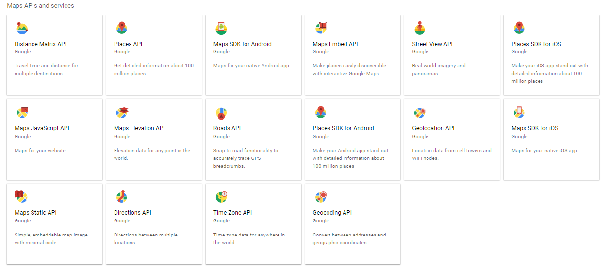
Google has about 16 Maps APIs as seen below...

Distance Matrix API - Travel time and distance for multiple destinations.
Places API - Get detailed information about 100 million places
Maps SDK for Android - Maps for your native Android app.
Maps Embed API - Make places easily discoverable with interactive Google Maps.
Street View API - Real-world imagery and panoramas.
Places SDK for iOS - Make your iOS app stand out with detailed information about 100 million places
Maps JavaScript API - Maps for your website
Maps Elevation API - Elevation data for any point in the world.
Roads API - Snap-to-road functionality to accurately trace GPS breadcrumbs.
Places SDK for Android - Make your Android app stand out with detailed information about 100 million places
Geolocation API - Location data from cell towers and WiFi nodes.
Maps SDK for iOS - Maps for your native iOS app.
Maps Static API - Simple, embeddable map image with minimal code.
Directions API - Directions between multiple locations.
Time Zone API - Time zone data for anywhere in the world.
Geocoding API - Convert between addresses and geographic coordinates.
In this case, Google has collected huge amount of data (most especially those data that relates to making and using maps) over the years.
Now, different clients or users across the world needs to access and make use of these data already collected by Google. So instead of these users passing through the pain of collecting these data by themselves, they will ask google to give them access to such data.
This is where an API comes into play. Via API, Google has exposed various map data to its users under various names. Here below are some of the Google API that are most useful in the GIS industry.
Google Maps APIs
Google has about 16 Maps APIs as seen below...
Distance Matrix API - Travel time and distance for multiple destinations.
Places API - Get detailed information about 100 million places
Maps SDK for Android - Maps for your native Android app.
Maps Embed API - Make places easily discoverable with interactive Google Maps.
Street View API - Real-world imagery and panoramas.
Places SDK for iOS - Make your iOS app stand out with detailed information about 100 million places
Maps JavaScript API - Maps for your website
Maps Elevation API - Elevation data for any point in the world.
Roads API - Snap-to-road functionality to accurately trace GPS breadcrumbs.
Places SDK for Android - Make your Android app stand out with detailed information about 100 million places
Geolocation API - Location data from cell towers and WiFi nodes.
Maps SDK for iOS - Maps for your native iOS app.
Maps Static API - Simple, embeddable map image with minimal code.
Directions API - Directions between multiple locations.
Time Zone API - Time zone data for anywhere in the world.
Geocoding API - Convert between addresses and geographic coordinates.
No comments:
Post a Comment