Basically, a database consists of an organized collection of data for one or more uses, typically in digital form.
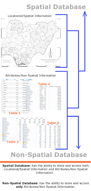
Spatial Database: has the ability to store and access both Location/Spatial Information and Attributes/Non-Spatial Information.
Non-Spatial Database: has the ability to store and access only Attributes/Non-Spatial Information.
The info-graphics below shows the difference in the concepts of Spatial and Non-Spatial databases.
Basically, the differences are in the storage, function, and query capabilities between the two. The notable differences are listed below;-
a) A spatial database supports special data types for geometric objects and allows you to store geometric data (usually of a geographic nature) in tables while a non-spatial database doesn't support such.
b) A spatial database provides special functions and indexes for querying and manipulating geospatial data using something like Structured Query Language (SQL) while non-spatial database doesn't provide such functions and indexes.
c) A spatial database is often used as a storage container for geospatial data, but it can do much more than that. While non-spatial database is often used as a storage container for non-spatial data.
d) A spatial database uses spatial query in geometric functions to answer questions about space and objects in space. While non-spatial database don't support spatial queries.
e) In addition to being able to answer questions about the use of space, spatial database functions allow you to create and modify objects in space. This portion of spatial analysis is often referred to as geometric or spatial processing.
f) A spatially enabled database can intrinsically work with data types like rivers (modeled as linestrings), land parcels (modeled as polygons), and trees (modeled as points). While non-spatial database can’t work with these forms of models.
There are several examples of Spatial and Non-spatial database servers available, but the top common once include:
a) SpatiaLite - SQLite
b) Oracle Spatial/Locator - Oracle
c) MySQL Spatial - MySQL
d) PostGIS - PostgreSQL
e) DB2 Spatial - IBM DB2/Informix
f) MsSQL Spatial - MsSQL server
g) Spatial Hadoop - Hadoop
h) MS Access - this is Non-spatial database, it has no support for Spatial database at the time of writing.
Note that Spatial databases are actually Non-spatial databases with spatial extension added onto them (I hope this makes sense). Anyway, study the pictures below, the first contains Non-spatial databases. After extending them with location/spatial capabilities, they then become Spatial databases.
Thanks for reading.
Spatial Database: has the ability to store and access both Location/Spatial Information and Attributes/Non-Spatial Information.
Non-Spatial Database: has the ability to store and access only Attributes/Non-Spatial Information.
The info-graphics below shows the difference in the concepts of Spatial and Non-Spatial databases.
Basically, the differences are in the storage, function, and query capabilities between the two. The notable differences are listed below;-
a) A spatial database supports special data types for geometric objects and allows you to store geometric data (usually of a geographic nature) in tables while a non-spatial database doesn't support such.
b) A spatial database provides special functions and indexes for querying and manipulating geospatial data using something like Structured Query Language (SQL) while non-spatial database doesn't provide such functions and indexes.
c) A spatial database is often used as a storage container for geospatial data, but it can do much more than that. While non-spatial database is often used as a storage container for non-spatial data.
d) A spatial database uses spatial query in geometric functions to answer questions about space and objects in space. While non-spatial database don't support spatial queries.
e) In addition to being able to answer questions about the use of space, spatial database functions allow you to create and modify objects in space. This portion of spatial analysis is often referred to as geometric or spatial processing.
f) A spatially enabled database can intrinsically work with data types like rivers (modeled as linestrings), land parcels (modeled as polygons), and trees (modeled as points). While non-spatial database can’t work with these forms of models.
Examples of Spatial and Non-spatial databases
There are several examples of Spatial and Non-spatial database servers available, but the top common once include:
a) SpatiaLite - SQLite
b) Oracle Spatial/Locator - Oracle
c) MySQL Spatial - MySQL
d) PostGIS - PostgreSQL
e) DB2 Spatial - IBM DB2/Informix
f) MsSQL Spatial - MsSQL server
g) Spatial Hadoop - Hadoop
h) MS Access - this is Non-spatial database, it has no support for Spatial database at the time of writing.
Note that Spatial databases are actually Non-spatial databases with spatial extension added onto them (I hope this makes sense). Anyway, study the pictures below, the first contains Non-spatial databases. After extending them with location/spatial capabilities, they then become Spatial databases.
Before getting location/spatial capabilities
After getting location/spatial capabilities
Thanks for reading.


No comments:
Post a Comment