
Maps and Plans are two common terms used in the GIS industry. And in most cases the people using the system don't bother to know the differences between a map and plan, so in this post I list some of the differences between a map and plan.
(a) A map is a visual representation of an area - a symbolic depiction highlighting relationships between elements of that space such as objects, regions, and themes.
Plans are a set of two-dimensional diagrams or drawings used to describe a place or object, or to communicate building or fabrication instructions. Usually plans are drawn or printed on paper, but they can take the form of a digital file.
(b) Although most commonly used to depict geography, maps may represent any space, real or imagined, without regard to context or scale; e.g. Brain mapping, DNA mapping, and extra-terrestrial mapping.
Plans are often for technical purposes such as architecture, engineering, or planning. Their purpose in these disciplines is to accurately and unambiguously capture all the geometric features of a site, building, product or component. Plans can also be for presentation or orientation purposes, and as such are often less detailed versions of the former. The end goal of plans is either to portray an existing place or object, or to convey enough information to allow a builder or manufacturer to realize a design.
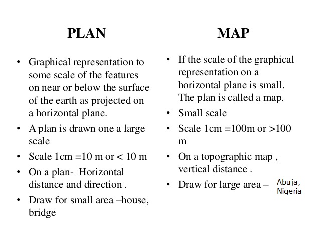
(c) Many but not all maps are drawn to a scale, allowing the reader to infer the actual sizes of, and distances between, depicted objects. A larger scale shows more detail, thus requiring a larger map to show the same area.
Plans are usually scale drawings, meaning that the plans are drawn at specific ratio relative to the actual size of the place or object. Various scales may be used for different drawings in a set. For example, a floor plan may be drawn at 1:50 (or 1/4"=1'-0") whereas a detailed view may be drawn at 1:25 (or 1/2"=1'-0"). Site plans are often drawn at 1:200 or 1:100
(d) To communicate spatial information effectively, features such as rivers, lakes, and cities need to be labeled. Over centuries cartographers have developed the art of placing names on even the densest of maps. Text placement or name placement can get mathematically very complex as the number of labels and map density increases. Therefore, text placement is time-consuming and labor-intensive, so cartographers and GIS users have developed automatic label placement to ease this process
Because plans represent three-dimensional objects on a two-dimensional plane, the use of views or projections is crucial to the legibility of plans. Each projection is achieved by assuming a vantage point from which to see the place or object, and a type of projection
(e) A plan generally works using a smaller scale while a map uses a larger scale as it generally covers larger areas.

(f) A plan is a true scale scale representation while a map is drawn such that some features on it cannot be drawn to scale. On a map many features are represented as symbols and generalization is carried out resulting in changes in scale and displacement of features. e.g on a 1:1 million map, rivers and roads may be shown but they cannot be drawn to scale. a 5m road would be 0.005mm wide if drawn according to scale.
(g) Plans tend to be for a single or few applications while maps cover a large vary of uses e.g in exploration, military, recreation, geological, navigation e.t.c
Thanks for reading
It is really very helpful for us and I have gathered some important information from this blog.
ReplyDeleteDifferenceBetween.com
Thanks,
ReplyDeleteThis post was handy.
I've been drawing maps for years and I never thought of this until someone asked me tonight.
Once again thanks.
Thanks for send very good answer
ReplyDeleteThanks this was enlighting for me.
ReplyDelete