Monday, April 11, 2016

AutoCAD Alternatives - for students and startups

There is no doubt whatsoever that AutoCAD is the most used Computer Aided Design program for people who need to create 2D and 3D drawings and diagrams, especially in industries such as architecture, interior design and engineering.

In this part of the world (Nigeria, Africa), AutoCAD is the most preferred option when it comes to choosing Computer Aided Design (CAD) software.
Some of the reasons that may push you considering other Computer Aided Design (CAD) software alternatives over AutoCAD include:
~ High cost of AutoCAD license
~ AutoCAD requires high volume of System Capacity and Configurations
~ Steep Learning curve of AutoCAD

With all these and other possible reasons in mind, I present to you Great Lists of Alternative CAD software to AutoCAD

Tuesday, April 5, 2016

Processing HTML form data with Python and PHP Script

In today's post, am going to work through "how to Process HTML form with Python and PHP Script".

Html forms on websites are processed using a server-side programming language such as PHP, Python, Ruby, Java, Asp, Perl etc. Therefore, your website server most have support for the programming language you wish to use in processing the form.

In this tutorial am going to use Apache web server on a local windows PC. You can run Apache on Windows via easy to use tools such as WAMP, XAMPP, or AMPPS.

I assumed you have the XAMPP web server and Python2 installed. However, you are free to use any of the web servers listed above with the compatible version of python.

Let's get started....

Html form

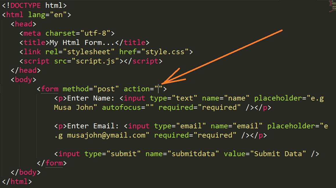
The html form we are going to use has just three (3) elements; two text fields and a submit button. The code for the form is as below;-


Note that the "action" attribute is empty, it most be changed accordingly in the next step for php or python.

Now go to your XAMPP htdocs directory and create a folder name it "project". That is your location will look like this: C:\xampp\htdocs\project. Copy the html code above and save it in a file named "myForm" with .html extension at this location "C:\xampp\htdocs\project" then move to the next stage of this tutorial below.

Result of the above code file on the browser is as the image below;-

Your file location should look like: http://localhost/project/myForm.html

Getting Started With Python Programming in GIMP


GIMP is a Free & Open Source Image Editor, an alternative to PhotoShop. GIMP has good support for python programming. This means you can extend the functionality of GIMP software or automate processes using costume scripts written in python.

To open the python shell from GIMP, goto the menu of Filters >> Python-Fu >> Console

This should open the python interactive environment as seen below;-


You can now code in python via GIMP to extend its functionality or automate its processes!

Thanks for reading

Monday, April 4, 2016

Getting Started With Python Programming in QGIS


How to start python Programming in QGIS, lets write a simple "Hello world!" script.

QGIS is one of the best open source GIS software available. It has support for scripting in Python programming language. This means you can extend the functionality of QGIS using costume scripts written in python.

You don't need to install python separately, if you install QGIS it comes with its own python set by default.

From the "Plugin" menu select "Python Console" to open the Python Console interface where yo can type and run python scripts in QGIS. You can also do this by clicking on the "Python Console" icon from the tools bar.


To print a simple "Hello world!" script, use the "Interactive Console" at the bottom as follow;-

Type print "Hello world!" on the "Interactive Console" and press "Enter" key or click "Run Command" button to display the result as seen below.


This is how to start "Python Console" and run python script in QGIS.

Thanks for reading.

Map of Nigeria in SHAPEFILE format for free

Do you want to get a detailed map of Nigeria or just any country in shapefile format? Then you are reading the right article.

When you search online for a map of Nigeria, the commonest results that shows up are images/pictures of map of Nigeria. As a GIS professional you would love to get a map in shapefile format and within its corrected geographical context.
Today, I will show you how to download the map of Nigeria in shapefile format.

What is a shapefile? 

Before I show you where you can get maps in shapefile format, lets quickly see what a shapefile is.

A shapefile is a simple, non-topological format for storing the geometric location and attribute information of geographic features. Geographic features in a shapefile can be represented by points, lines, or polygons (areas). Shapefile is developed and regulated by Esri as a (mostly) open specification for data interoperability among Esri and other GIS software products. 

A shapefile isn't just a single file but it is made up of a collection of files with a common filename prefix, stored in the same directory/folder. The three mandatory files have filename extensions .shp, .shx, and .dbf. The actual shapefile relates specifically to the .shp file, but alone is incomplete for distribution as the other supporting files are required.

For example, complete Nigeria shapefile will be these files: NGA_adm0.shpNGA_adm0.shx and NGA_adm0.dbf

Downloading map of Nigeria in shapefile format

To get this map, you need to visit one of the Spatial Data providers to download it. I will recommend DIVA-GIS as I have downloaded several Free Spatial Data from there.

So head over to DIVA-GIS and select Free Spatial Data then Download country level data


Select the "Country" and the "Subject" you want and click "Ok" to start downloading your maps in shapefile.

That is all you need to do!

If you need any mapping customization feel free to contact me on 08039508010 or through my website www.umaryusuf.com


Thanks for reading and happy mapping.

Sunday, April 3, 2016

How to Run Python on XAMPP web server

Today, am going to talk abut "Running Python Scripts on Windows with Apache and Xampp web server".

One of the easiest ways to get Apache web server on a local windows PC is through an easy to use tool called XAMPP. Other tool that provide Apache web server on PC are WAMP or AMPPS.

While PHP and Perl are automatically installed with the XAMPP server as at the time of writing, XAMPP installation doesn't come with Python by default, hence we have to we have to add python support manually. On the other hand, the AMPPS web server includes Python if you decided to use it.

XAMPP stands for Cross-Platform (X), Apache (A), MySQL (M), PHP (P) and Perl (P). It is a simple, lightweight Apache distribution that makes it extremely easy for developers to create a local web server for testing purposes.

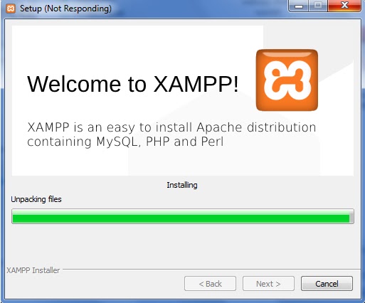
Now download and install latest version of XAMPP if don't have it.


Next download and install Python, for this purpose am going to use Python2.7.10. Make sure you select "add python.exe to Path" to add your python set to the system PATH.


I assume you have installed both xampp and python on the C Drive:
c:/xampp
c:/python27 or c:/python35


In order to deliver dynamic contents on the web using python with the XAMPP server, we need a mechanism to do this? This mechanism could be either of WSGI or CGI or FastCGI or sCGI etc.

Monday, March 7, 2016

70+ Free Python Programming Language Learning Resources

Hello,

Today, I present to you over 70 useful materials for learning the worlds dynamic and strongly typed programming language that is designed to emphasize usability, Python! The list contains two similar but incompatible versions of Python in widespread use (2 and 3).

2)    A Guide to Python's Magic Methods - Rafe Kettler
3)    Automate the Boring Stuff - Al Sweigart
4)    Biopython (PDF)
6)    Building Skills in Python (PDF) (2.6)
7)    Byte of Python (2.7.x)
10) Composing Programs (3.x)
12) Dive into Python - Mark Pilgrim (2.3)
13) Dive into Python 3 - Mark Pilgrim (3.0)
15) Google's Python Class (2.4 - 2.x)
17) Hacking Secret Cyphers with Python - Al Sweigart (3.3)
20) How to Think Like a Computer Scientist: Learning with Python - Allen B. Downey, Jeff Elkner and Chris Meyers (2.4)
21) Intermediate Python - Muhammad Yasoob Ullah Khalid (1st edition)
22) Introduction to Programming Using Python - Cody Jackson (1st edition) (2.3)
24) Introduction to python - Kracekumar (2.7.3)
28) Learn Python The Hard Way (2.5 - 2.6)
29) Learn to Program Using Python - Cody Jackson (PDF)
31) Learning to Program with Python - Richard L. Halterman (PDF) (3.2)
33) Making Games with Python & Pygame - Al Sweigart (2.7)
34) Modeling Creativity: Case Studies in Python - Tom D. De Smedt (PDF)
38) Porting to Python 3: An In-Depth Guide (2.6 - 2.x & 3.1 - 3.x)
39) Practical Programming in Python - Jeffrey Elkner (PDF)
40) Problem Solving with Algorithms and Data Structure using Python - Bradley N. Miller and David L. Ranum

Thursday, March 3, 2016

Web-Based Mapping with QGIS

Web-Based Mapping with QGIS

Web-based mapping has never been easy as it is now. What would have taken several months of coding in languages such as C++, Python or Java can now be done within a few clicks lasting not more than 10 minutes.

Thanks to QGIS web mapping plugin such as: qgis2web, qgis2leaf, qgis2threejs, Lizmap and OpenLayers plugin. These plugins makes it incredibly easy to create a basic, fully-functional LeafletJS map using QGIS with no HTML, JavaScript, or CSS programming skills.

In this tutorial, am going to work you through basic process of creating your very first web-based map like this:-

So this tutorial is for all those who had always cared for the ambition of being able to create their very own web map and publish from their websites.

To archive this, follow this simple step-by-step tutorial.

Download dataset: am using the point shapefile containing states capital cities in Nigeria available at: https://www.dropbox.com/s/vmj276zrhaca2sv/WebMap_QGIS.zip?dl=0

Feel free to use whatever dataset you want to.

Step 1:
Download and install the latest version of QGIS. Mine is: QGIS 2.12.3-Lyon

Step 2:
Install any of the QGIS web map plugin. I will use the qgis2web plugin for this guide. QGIS2web is a plugin to export your project to an OpenLayers 3 or Leaflet web map. No server-side software is required.

Step 3:
From the menu bar, go to PLUGINS > MANAGE AND INSTALL PLUGINS…
Search for the “qgis2web” plugin, select it and click on “Install Plugin”.


Step 4: 
In QGIS, add your shapefiles layers of interest and style them just the way you want. Prepare your map as far as possible in QGIS, as you want it to appear in your web map.
In my case I added the cities point shapefile and the state polygon shapefile as seen below.


Step 5:
Now go to MENU > WEB and from the drop dropdown list, select "qgis2web" then select “Create Web Map”.
~ This should open a dialog displaying your map preview and settings to the left side panel.
~ For each of the layers in your project, you can show number of attributes field that will be displayed whenever mouse is clicked on a feature from the layer.
~ In the next section setup your data export location, zooming scale, and the appearance. As you make the settings, you can use the “update preview” button to see how your web map will appear.

Step 6:
If you are done, click on the “Export” button to your map into .html file with its accompanying files and folders.


Step 7:
Register a domain name and a hosting account to the contents of the folder above into your server. Your web map will then be accessible through the web address you registered.


That is it.
Post Comments if your have any.
Thanks for reading.

Wednesday, January 13, 2016

How to Pay SCHOOL FEES for Ahmadu Bello University (ABU) Zaria returning students - Electronic Invoice payable by REMITA.NET (2015/2016 Session)

How to Pay SCHOOL FEES for Ahmadu Bello University (ABU) Zaria returning students - Electronic Invoice payable by REMITA.NET (2015/2016 Session)


Logon to the school’s portal with your correct UserName and Password at: https://portal.abu.edu.ng/


Click on “School Fees” tab


Click on the Session you want to pay for in this case it is (2015/2016 SESSION: Registration fees Not Paid) as seen below


From the new window that opens, click on “Pay via Remita”

Tuesday, January 5, 2016

How to calculate GPA and CGPA

How to calculate GPA and CGPA for Nigerian Polytechnics and Colleges of Education

GPA and CGPA Guide
This is based on four (4) point scale as used by most Nigerian Polytechnics and Colleges of Education.
Academic excellence in Nigerian Polytechnics is measured using the Grade Point Average (GPA) and Cumulative Grade Point Average (CGPA). So it is important that all students have insight on how to calculate their GPA & CGPA so as to be able to evaluate their academic performance from time to time and improve.

GRADING SYSTEM
Scores
Grade Letter
Weight
80 - 100
A
4.0
70 - 79
AB
3.5
60 - 69
B
3.0
50 - 59
BC
2.5
40 - 49
C
2.0
30 - 39
CD
1.5
20 - 29
D
1.0
10 - 19
E
0.5
00 - 09
F
0.0


Note: Other institutions such as Universities that use different point scale (usually 5 or 7 points), will have different grading system.

Class of Degree
3.50 – 4.00
Distinction
3.00 – 3.49
Credit
2.50 – 2.99
Merit
2.00 - 2.49
Pass
Below 2.00
Fail


The next section will guide you on using software in calculating your GPA and CGPA before we talk about manually perform the same calculation.